Here are all the big changes to Apple Maps from 2017 through 2019

Apple is continually updating Apple Maps, bringing in new features and expanding coverage with its own fleet of mapping vehicles. Here's what the company's been adding since 2017 to present, updated on April 25 with enhanced details in the US northeast.
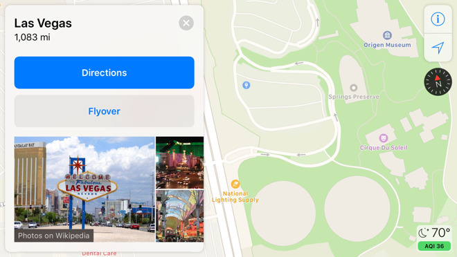
Apple's first-party maps are now being used in Arizona, New Mexico, and southern Nevada, most importantly including Las Vegas. The data comes from the company's special recon vehicles, and should let people see greater urban and natural details.
Since Apple ditched Google Maps data in 2012, the company has been reliant on a mashup of third-party sources in most regions. Its first-party coverage began in California in 2018.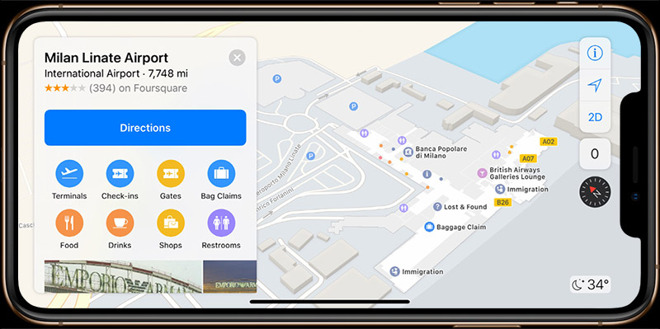
Transit directions are now available in Alaska, Connecticut, Delaware, Florida, Georgia, Illinois, Indiana, Kentucky, Mississippi, Missouri, New Jersey, New York, North Dakota, Oklahoma, Rhode Island, South Dakota and Texas.
In addition, Indoor Maps has extended coverage to more than 40 malls in Australia, Italy, Japan and the U.S., as well as three airports -- Fort Lauderdale-Hollywood International Airport (FLL), Newcastle International Airport (NCL) and Milano Linate Airport (LIN).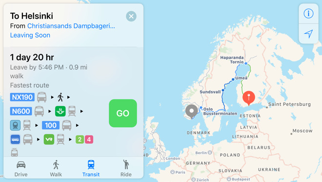
Public transit directions are now finally available across Denmark, Finland, Norway, and Sweden, filling in major gaps in European coverage. Riders can get directions not just for buses and trains but trams and even funiculars (ascending cable cars).
Europe is still poorly covered in terms of transit. The only other fully-covered countries include Belgium, Estonia, Ireland, Luxembourg, the Netherlands, Switzerland, and the U.K.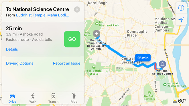
Turn-by-turn directions have finally come to the world's second-biggest country, India. The option gives iPhone and Apple Watch owners a built-in way of navigating India's sometimes complicated road system.
Apple has simultaneously added the ability for Indians to hail Uber and Ola rides in-app, which previously required switching out.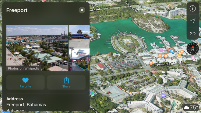
Indoor maps have been added for dozens of malls in the U.S. and abroad, and North Carolina's Raleigh-Durham International Airport.
3D Flyover graphics have been added for locations peppered throughout France, Japan, England, Italy, Spain, the U.S., and elsewhere. Some of the more prominent examples include Albuquerque, Charleston, Cincinnati, Freeport (Bahamas), Granada, Greensboro, Joshua Tree National Park, Key West, Lake Tahoe, Monaco, Padua, Queenstown (New Zealand), and Toledo (Ohio).
-----
Public transit directions are now available across the U.S. states of Iowa and Wyoming, as well as in Belgium, Switzerland, and Manila in the Philippines.
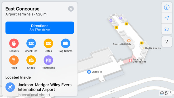
Indoor maps have meanwhile been added for several more airports, including Brisbane (BNE), Central Japan International, Tokyo Narita International, Cincinnati/Northern Kentucky International, Hartsfield-Jackson Atlanta International, Jackson-Medgar Wiley Evers International, and Melbourne (MEL).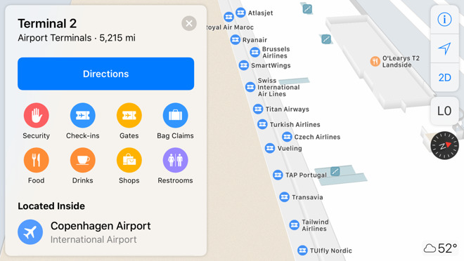
Over 20 new indoor maps are available, with most being malls in Georgia and Kentucky, including four in Atlanta alone. Other Georgia cities include Alpharetta, Buford, Macon, Savannah, and Columbus, while the Kentucky locations are in Louisville, Elizabethtown, Florence, and Bowling Green.
Outside the U.S. Apple has added Toronto's Eaton Centre, Singapore's Anchorpoint, and four malls in Hong Kong.
Two new airports are Copenhagen in Denmark, and Sky Harbor International in Phoenix, Ariz.
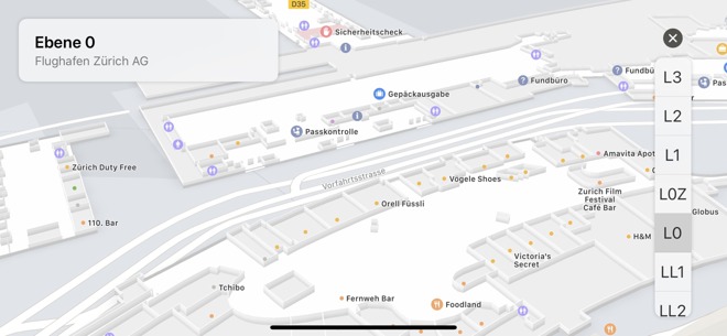
Residents of Switzerland can now finally get public transit directions, including indoor maps for stations and connections to international routes, MacPrime says. Apple has also introduced an indoor map for Zurich Airport, making it possible to find gates, security checks, and various amenities in 2D or 3D.
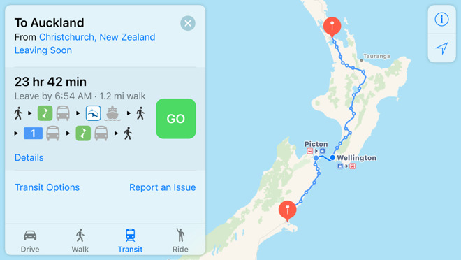
Public transit directions are now available across most urban areas in New Zealand, including local options, as well as InterCity buses and Great Journeys ferries and trains.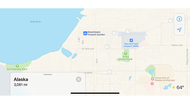
Users in Alaska, Idaho and Wyoming now have access to public transit directions within Apple Maps. Support is limited largely to bus routes in larger metropolitan areas like Anchorage in Alaska and Cheyenne in Wyoming, though an expansion to other areas within the respective states are expected.
Apple flipped the switch on indoor maps in Japan, bringing the anticipated feature to international airports Narita Airport in Chiba and Chubu Centrair Airport in Nagoya, reports Ata Distance. The rollout is similar to past indoor maps launches in the U.S., where significant regional transportation venues like airports, train stations and subways saw early support.
Indoor maps now cover Finland's Helsinki Airport, Canada's Halifax Stanfield International Airport, and three U.S. airfields, namely Logan International in Boston, Dallas-Fort Worth International, and Dallas Love Field. Mall maps have been expanded to select Miami and Phoenix locations, and the Spanish cities of Barcelona, Bilbao, and Madrid.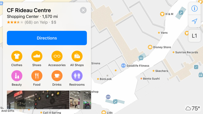
Canadian users have gained indoor maps for some 18 shopping malls in cities like Calgary, Toronto, Montreal, Ottawa, and Vancouver. All but one are Cadillac Fairview (CF) properties, the exception being Mississauga's Square One.
Transit directions are now available in areas of Vermont, New Hampshire, Maine and Michigan.
Transit directions are now availabile in the country of Luxembourg, as well as more cities in Oregon, Texas, Washington, and Pennsylvania. In Canada Apple has finally added support for VIA Rail, the country's most ubiquitous rail company with a presence spanning eight provinces.
In a rarer international push with Apple's public transit data, directions are now available in the Italian capital, Rome, as well as the northern European country of Estonia.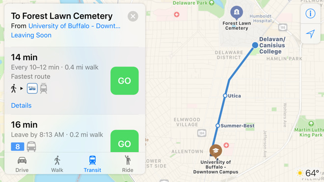
Buffalo joined other parts of New York state in transit support.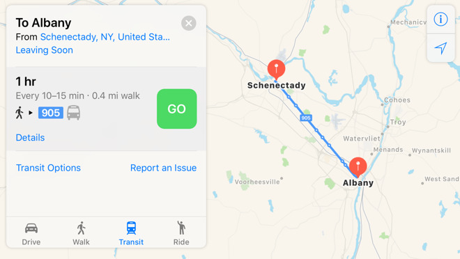
Transit directions are now available in upstate New York, including areas like Albany.
Developers can now embed Apple Maps within websites via the MapKit JS beta.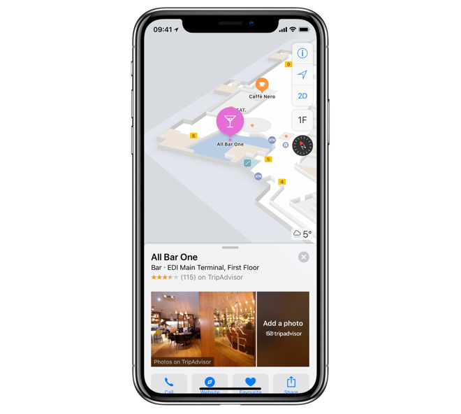
Updates this month included statewide public transit for Arkansas, Ohio, Maryland, West Virginia, and Tennessee, as well as lane guidance in Finland, Hungary, Ireland, Poland, and the Czech Republic. New indoor airport maps covered Edinburgh (EDI), Sydney International (SYD), and Hamad International (DOH) in Doha, Qatar.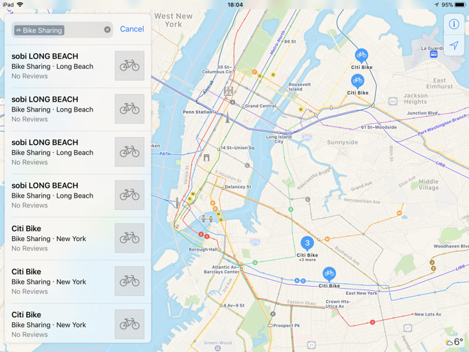
Locations for bike-sharing services were added for 175 cities in 36 countries, such as Barcelona, Montreal, and New York City.
-----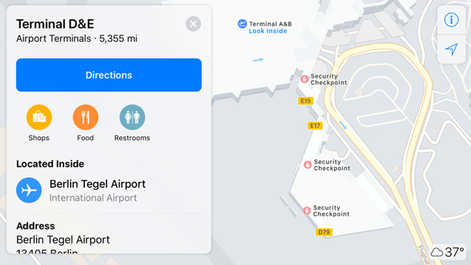
Berlin's Tegel.
New indoor airport maps included Berlin's Tegel and Schoenefeld, London's Heathrow and Gatwick, Amsterdam's Schiphol, and Geneva in Switzerland.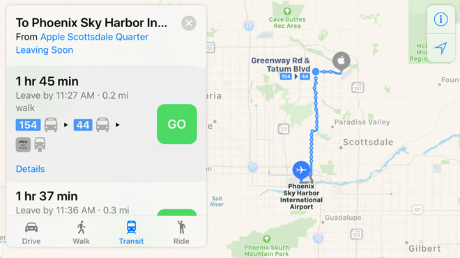
Public transit directions were added for Phoenix, Ariz.
Ireland picked up transit support as well.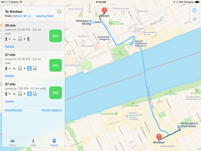
Transit was enabled for Detroit in the U.S. and its connected Canadian city, Windsor.
August 13
In an extension of first-party Apple Maps, the new data is now being used from just south of Washington D.C. to the Canadian border. As with the previous data, the information is coming from Apple's fleet of vehicles and has much deeper details on locations serviced.August 9
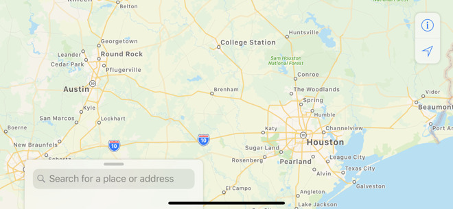
In a large upload, Apple is now using first-party map data along a large swath of the US southwest. The new data spans parts of Louisiana, Mississippi, and Texas. Areas covered by the enhanced map data are lightly shaded in green on a map overview.April 25
Apple's first-party maps are now being used in Arizona, New Mexico, and southern Nevada, most importantly including Las Vegas. The data comes from the company's special recon vehicles, and should let people see greater urban and natural details.
Since Apple ditched Google Maps data in 2012, the company has been reliant on a mashup of third-party sources in most regions. Its first-party coverage began in California in 2018.
Feb. 5
Transit directions are now available in Alaska, Connecticut, Delaware, Florida, Georgia, Illinois, Indiana, Kentucky, Mississippi, Missouri, New Jersey, New York, North Dakota, Oklahoma, Rhode Island, South Dakota and Texas.
In addition, Indoor Maps has extended coverage to more than 40 malls in Australia, Italy, Japan and the U.S., as well as three airports -- Fort Lauderdale-Hollywood International Airport (FLL), Newcastle International Airport (NCL) and Milano Linate Airport (LIN).
Jan. 21
Public transit directions are now finally available across Denmark, Finland, Norway, and Sweden, filling in major gaps in European coverage. Riders can get directions not just for buses and trains but trams and even funiculars (ascending cable cars).
Europe is still poorly covered in terms of transit. The only other fully-covered countries include Belgium, Estonia, Ireland, Luxembourg, the Netherlands, Switzerland, and the U.K.
Jan. 10
Turn-by-turn directions have finally come to the world's second-biggest country, India. The option gives iPhone and Apple Watch owners a built-in way of navigating India's sometimes complicated road system.
Apple has simultaneously added the ability for Indians to hail Uber and Ola rides in-app, which previously required switching out.
Jan. 9, 2019
Indoor maps have been added for dozens of malls in the U.S. and abroad, and North Carolina's Raleigh-Durham International Airport.
3D Flyover graphics have been added for locations peppered throughout France, Japan, England, Italy, Spain, the U.S., and elsewhere. Some of the more prominent examples include Albuquerque, Charleston, Cincinnati, Freeport (Bahamas), Granada, Greensboro, Joshua Tree National Park, Key West, Lake Tahoe, Monaco, Padua, Queenstown (New Zealand), and Toledo (Ohio).
-----
Dec. 19, 2018
Public transit directions are now available across the U.S. states of Iowa and Wyoming, as well as in Belgium, Switzerland, and Manila in the Philippines.
Indoor maps have meanwhile been added for several more airports, including Brisbane (BNE), Central Japan International, Tokyo Narita International, Cincinnati/Northern Kentucky International, Hartsfield-Jackson Atlanta International, Jackson-Medgar Wiley Evers International, and Melbourne (MEL).
Nov. 2, 2018
Over 20 new indoor maps are available, with most being malls in Georgia and Kentucky, including four in Atlanta alone. Other Georgia cities include Alpharetta, Buford, Macon, Savannah, and Columbus, while the Kentucky locations are in Louisville, Elizabethtown, Florence, and Bowling Green.
Outside the U.S. Apple has added Toronto's Eaton Centre, Singapore's Anchorpoint, and four malls in Hong Kong.
Two new airports are Copenhagen in Denmark, and Sky Harbor International in Phoenix, Ariz.
Oct. 25, 2018
Residents of Switzerland can now finally get public transit directions, including indoor maps for stations and connections to international routes, MacPrime says. Apple has also introduced an indoor map for Zurich Airport, making it possible to find gates, security checks, and various amenities in 2D or 3D.
Sept. 20, 2018
Public transit directions are now available across most urban areas in New Zealand, including local options, as well as InterCity buses and Great Journeys ferries and trains.
Sept. 10, 2018
Users in Alaska, Idaho and Wyoming now have access to public transit directions within Apple Maps. Support is limited largely to bus routes in larger metropolitan areas like Anchorage in Alaska and Cheyenne in Wyoming, though an expansion to other areas within the respective states are expected.
Sept. 6, 2018
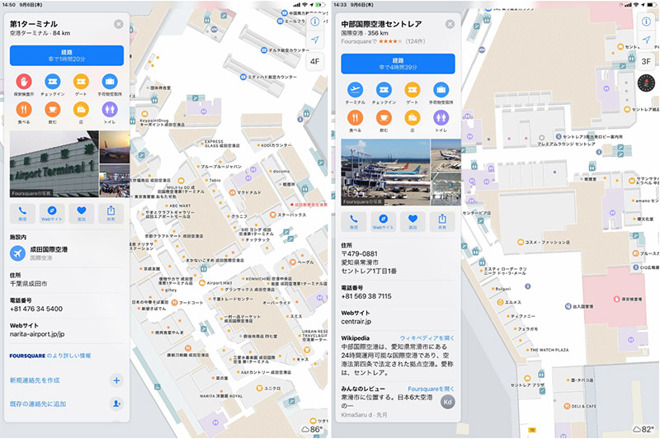
Apple flipped the switch on indoor maps in Japan, bringing the anticipated feature to international airports Narita Airport in Chiba and Chubu Centrair Airport in Nagoya, reports Ata Distance. The rollout is similar to past indoor maps launches in the U.S., where significant regional transportation venues like airports, train stations and subways saw early support.
Aug. 23, 2018
Indoor maps now cover Finland's Helsinki Airport, Canada's Halifax Stanfield International Airport, and three U.S. airfields, namely Logan International in Boston, Dallas-Fort Worth International, and Dallas Love Field. Mall maps have been expanded to select Miami and Phoenix locations, and the Spanish cities of Barcelona, Bilbao, and Madrid.
Aug. 15, 2018
Canadian users have gained indoor maps for some 18 shopping malls in cities like Calgary, Toronto, Montreal, Ottawa, and Vancouver. All but one are Cadillac Fairview (CF) properties, the exception being Mississauga's Square One.
Transit directions are now available in areas of Vermont, New Hampshire, Maine and Michigan.
Aug. 2, 2018
Transit directions are now availabile in the country of Luxembourg, as well as more cities in Oregon, Texas, Washington, and Pennsylvania. In Canada Apple has finally added support for VIA Rail, the country's most ubiquitous rail company with a presence spanning eight provinces.
June 25, 2018
In a rarer international push with Apple's public transit data, directions are now available in the Italian capital, Rome, as well as the northern European country of Estonia.
June 20, 2018
Buffalo joined other parts of New York state in transit support.
June 14, 2018
Transit directions are now available in upstate New York, including areas like Albany.
June 6, 2018
Developers can now embed Apple Maps within websites via the MapKit JS beta.
Apr. 2018
Updates this month included statewide public transit for Arkansas, Ohio, Maryland, West Virginia, and Tennessee, as well as lane guidance in Finland, Hungary, Ireland, Poland, and the Czech Republic. New indoor airport maps covered Edinburgh (EDI), Sydney International (SYD), and Hamad International (DOH) in Doha, Qatar.
March 27, 2018
New transit data covered metropolitan areas in Missouri and Virginia.March 21, 2018
Transit expanded again, this time to Albuquerque, N.M.March 19, 2018
Transit support was activated across West Virginia.March 14, 2018
Transit data was added for Orlando, Fla., and some portions of Arkansas.March 12, 2018
Locations for bike-sharing services were added for 175 cities in 36 countries, such as Barcelona, Montreal, and New York City.
Feb. 28, 2018
Lane guidance in Austria, South Africa, and Switzerland.Feb. 27, 2018
Transit directions for urban areas in South CarolinaFeb. 12, 2018
Public transit directions were added for Tuscon, Ariz.Jan. 29, 2018
The latest transit expansions: Milwaukee, Wis., and Omaha, Neb.-----
Dec. 13, 2017
Apple confirmed that 43 locations were offering indoor maps, among them 34 airports and several malls in cities like Boston, Los Angeles, New York, and San Francisco.Dec. 5, 2017
Transit directions became available in Tampa, Fla.Nov. 30, 2017
Berlin's Tegel.
New indoor airport maps included Berlin's Tegel and Schoenefeld, London's Heathrow and Gatwick, Amsterdam's Schiphol, and Geneva in Switzerland.
Oct. 30, 2017
Public transit directions were added for Phoenix, Ariz.
Oct. 18, 2017
Apple added indoor maps for several U.S. airports: O'Hare International and Midway International in Chicago, Miami International, Oakland International, Las Vegas's McCarran International, and Minneapolis-Saint Paul International.Oct. 17, 2017
Transit was a go for Birmingham, Ala.Oct. 16, 2017
Ireland picked up transit support as well.
Oct. 12, 2017
Transit directions arrived in the country of Taiwan.Aug. 7, 2017
Australian coverage improved with large sections of the states of Queensland and Western Australia.July 10, 2017
The state of Nevada got expanded transit support, covering cities like Las Vegas and Reno.June 27, 2017
Transit directions were turned on for Madrid, Spain.May 22, 2017
Apple enhanced its transit data for the Netherlands with more details for stations and tracks, though not live train and bus data.May 15, 2017
Transit options were expanded to Adelaide, Australia.May 9, 2017
Transit directions came to the city-state of Singapore in preparation for the region's first Apple store.Apr. 24, 2017
Paris picked up general public transit directions. Saudi Arabia and the United Arab Emirates, meanwhile, saw their first access to live traffic data.Apr. 19, 2017
Apple began showing public bike rental stations in London, Paris, and New York, as well as EV charging stations in the U.K., the latter by way of data from Moovility.Feb. 13, 2017
Transit was enabled for Detroit in the U.S. and its connected Canadian city, Windsor.
Comments
That's so annoying!
I went to a funeral yesterday up on the mountain. Google gave me directions for public transport right down to the unique identifier of the bus stop and the minutes to wait for the next bus. Updated in real time to reflect delays caused by traffic.
It's a pity; Google Maps has the data, but doesn't have first-class integration with Apple Watch + AirPods. Nothing’s quite perfect.
• Telling me to take the freeway when it’s all torn up down to the gravel, while the State of Michigan is completely rebuilding it.
• Directing me to get off the road to take a longer road, of equal quality and speed, to then redirect me back on the same road in less than 300 feet, when the road I was on was shorter, faster and of the same or better quality.
And it would also be nice if it knew about the speed limits, and either gave me an option to have them displayed, or provided an over speed indicator or audible warning. With settings similar to the recently departed NAVIGON App.
And the issues go on, but basic navigation guidance should always be its primary function.
- Directing to a senseless route is annoying, but to be fair, Google Maps does it too. In Maryland on Rout 270, the GPS keeps asking you to take the next exit, then asks you to merge back on to the highway. It does that for like 8 or 10 exits, Apple Maps and Google Maps do it the same. I think it has to do with how the map layers were built/coded by the city.
It really all depends on where you live. I experience quite the opposite.