Apple updating New York City map with greater detail, Look Around [u]

Posted:
in General Discussion edited September 2019
Apple has begun the roll-out of its updated maps for New York City, which include more transit information, better landmark detail, and also Look Around.

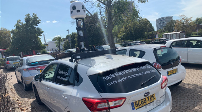
An Apple Maps car photographed in England in summer 2019


On Monday, Apple began rolling out its improved Apple Maps coverage of New York. The update is rolling out in phases according to Apple, and at the time of publication still isn't available to everyone in New York City yet. However, for some users the service is beginning to show the increased detail promised from Apple's program.

The improved coverage is also due to bring Apple's Look Around feature to New York, which mimics Google Street View to show how a journey would look on the ground.

"We have been driving and flying all across the United States, collecting land and aerial data to add significant new detail to the map, said Meg Frost, Apple's director of product design, at the launch of the new Maps in June.

Apple has reportedly only recently been undertaking its own photography, which means the company is more than a decade behind Google.

New York is the latest city to be updated, and follows others including Cupertino, San Francisco and Las Vegas.

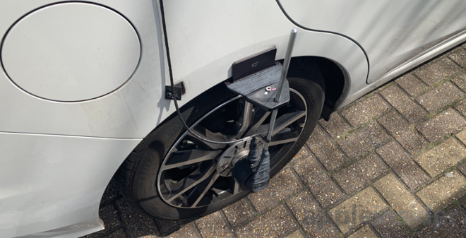
Detail of the sensors attached to the wheels on an Apple Maps car


The updated maps detail is part of a relaunched Apple Maps which was released for iOS 13 and iPadOS 13. Apple continues to develop Apple Maps, with recent patents suggesting the company is investigating the use of virtual or augmented reality to aid navigation.

Update: Apple's Look Around feature is also coming to Los Angeles.

Comments

  • Reply 1 of 10
    larryjwlarryjw Posts: 1,031member
    We just returned from a four day trip to NYC Manhattan. Maybe navigation in this part of the city can be improved with the current technology and Apple’s recent patents. I hope so.

    Navigation quality in Manhattan is quite uneven, to be generous. I don’t think it is possible for our devices to know with any accuracy where it is located. It’s the EMR noise of signals bouncing off the buildings, signal filtering, monster buildings preventing signals from every getting down to the street level. And, if you’re on the 19th floor of some building, the signals your phone will receive can tell it you’re located a couple of blocks away.

    Now, at 1500 7th Ave, I connected Wi-Fi to the Starbucks/Google system at that address that would allow automatic connection at any Starbucks in the city as you get near, so I’m assuming Starbucks has fairly accurate location signaling set up. To navigate in NYC I think this technology would need to be ubiquitous. 

     Bluetooth/iBeacon would work, but accurate location data might have to await high frequency 5G with multiple antennas in every block and around corners. 
    doozydozenwatto_cobraphilboogie
  • Reply 2 of 10
    larryjw said:
    We just returned from a four day trip to NYC Manhattan. Maybe navigation in this part of the city can be improved with the current technology and Apple’s recent patents. I hope so.

    Navigation quality in Manhattan is quite uneven, to be generous. I don’t think it is possible for our devices to know with any accuracy where it is located. It’s the EMR noise of signals bouncing off the buildings, signal filtering, monster buildings preventing signals from every getting down to the street level. And, if you’re on the 19th floor of some building, the signals your phone will receive can tell it you’re located a couple of blocks away.

    Now, at 1500 7th Ave, I connected Wi-Fi to the Starbucks/Google system at that address that would allow automatic connection at any Starbucks in the city as you get near, so I’m assuming Starbucks has fairly accurate location signaling set up. To navigate in NYC I think this technology would need to be ubiquitous. 

     Bluetooth/iBeacon would work, but accurate location data might have to await high frequency 5G with multiple antennas in every block and around corners. 
    I'm no expert, but go research Ultra-wideband support on the iPhone. That sounds like it will help in such a situation. example: https://gizmodo.com/what-is-ultra-wideband-and-what-does-it-do-in-the-iphon-1838097808
    watto_cobraAppleExposed
  • Reply 3 of 10
    cornchipcornchip Posts: 1,950member
    This is the slowest rollout of all time. My city doesn’t even have flyover yet! 🙄
    AppleExposed
  • Reply 4 of 10
    LOL. "Apple has reportedly only recently been undertaking its own photography, which means the company is more than a decade behind Google." The inaccuracy of this statement on an Apple related website is astounding. Apple began "photographing" years ago as it undertook to build its own base map to replace the conglomeration of vendors that Scott Forstall hastily put together with disastrous results. Apple has now finally completed the base map, work still to be done, and that's why we are seeing them roll out features like Look Around, which is the effort of YEARS of photography, and there is universal agreement that it blows Google's Street View out of the water. Indeed, Apple has completed huge phases of photography such that it is now moving on to videoing pedestrian pathways in the US.
    edited September 2019 watto_cobraAppleExposed
  • Reply 5 of 10
    razorpitrazorpit Posts: 1,796member
    cornchip said:
    This is the slowest rollout of all time. My city doesn’t even have flyover yet! ߙ䦬t;/div>
    Hey these things take time and 'money'. ;)

    Seriously though you would think they would have been able to cover most of the States by now. Those maps are extremely helpful, and probably cost next to nothing to produce (relatively speaking compared to driving every road in the US).
    edited September 2019 cornchipwatto_cobra
  • Reply 6 of 10
    larryjw said:
    We just returned from a four day trip to NYC Manhattan. Maybe navigation in this part of the city can be improved with the current technology and Apple’s recent patents. I hope so.

    Navigation quality in Manhattan is quite uneven, to be generous. I don’t think it is possible for our devices to know with any accuracy where it is located. It’s the EMR noise of signals bouncing off the buildings, signal filtering, monster buildings preventing signals from every getting down to the street level. And, if you’re on the 19th floor of some building, the signals your phone will receive can tell it you’re located a couple of blocks away.

    Now, at 1500 7th Ave, I connected Wi-Fi to the Starbucks/Google system at that address that would allow automatic connection at any Starbucks in the city as you get near, so I’m assuming Starbucks has fairly accurate location signaling set up. To navigate in NYC I think this technology would need to be ubiquitous. 

     Bluetooth/iBeacon would work, but accurate location data might have to await high frequency 5G with multiple antennas in every block and around corners. 
    NYC is probably the easiest big city to navigate due to the numbered blocks and extensive grid layout. Despite the common belief we are  supposedly rude we are always happy to tell people where to go. 
    edited September 2019 doozydozenphilboogiemuthuk_vanalingamAppleExposed
  • Reply 7 of 10
    cornchipcornchip Posts: 1,950member
    spice-boy said:

    we are always happy to tell people where to go. 

    🤔 hah iswydt  😂😬


    lolliverAppleExposed
  • Reply 8 of 10
    cornchipcornchip Posts: 1,950member
    razorpit said:
    cornchip said:
    This is the slowest rollout of all time. My city doesn’t even have flyover yet! ߙ䦬t;/div>
    Hey these things take time and 'money'. ;)

    Seriously though you would think they would have been able to cover most of the States by now. Those maps are extremely helpful, and probably cost next to nothing to produce (relatively speaking compared to driving every road in the US).
    Yeah I don’t really get it. Maybe it’s difficult to get airtime? Local authorities don’t want them taking pics of their cities? Some other regulatory red tape?
    watto_cobra
  • Reply 9 of 10
    I started seeing the new details and updated driving directions in Long Island, NY as well. Stop signs and traffic lights are showing up at their respective locations, and the spoken directions go as far as saying at the light/stop sign make a right/left. 


    watto_cobraAppleExposed
  • Reply 10 of 10
    I hope Apple lets its own customers add to the Look Around map of their local areas the way Google does with its Streetview maps. Google's method is a bit awkward to create but the results are great.
Sign In or Register to comment.