Apple Maps cars use LiDAR, Mac Pro to capture street data

Details of the working practices for drivers of Apple's fleet of mapping vehicles have been revealed, showing how the company's cars capture 3D data for Apple Maps and for training its self-driving vehicle systems, using custom iPads and a Mac Pro.
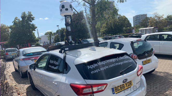
Cars mapping for Apple Maps have been periodically spotted on the roads, capturing routes and other data about local areas that can be used in Apple's navigational products. In a report describing how the system works, it is revealed that drivers have to abide by quite strict and secretive requirements while capturing the data.
Internal materials provided to 9to5Mac reveal that Apple uses two different types of vehicles as part of the initiative, as part of Apple's 3D Vision team. One is the self-driving Lexus that are used as part of Apple's autonomous driving program for the "Apple Car," codenamed "TycheEach," while another is a modified Subaru Impreza primarily for capturing data, known internally as "Ulysses."
The Subarus are fitted with a tower on the roof containing a combination of high-resolution cameras fitted with Zeiss lenses and LiDAR scanners, with data processed in real time via an onboard 2013 Mac Pro. A modified iPad referred to as the EyeDrive unit controls capture, as well as instructing operators on their tasks.
The EyeDrive app is used to say where the driver has to travel in the vehicle, while a secondary operator checks captured images and data for quality and marking if a street cannot be accessed. A mountain of data is captured by the system, with it filling a collection of four SSDs measuring 4 terabytes each per week.
The teams are under strict instructions to start capturing data at times of day when the sun is at, or above 30 degrees from the horizon, as the sun could interfere with the LiDAR sensors at shallow angles. Captures also must be performed under ideal weather conditions, so that the captured images are consistent with previous versions.
To ensure a level of privacy for the operation, the cars are stored at specific safe locations that it does not reveal. The secrecy behind the locations extends to building owners, who end up renting properties to an Apple-owned front company.
Images captured are used for a number of purposes, such as to train self-driving vehicle software how to read and interpret the road. For consumers, the same data is used to power features such as Flyover and Look Around.
Comments
Old Map
New Map
The angles they have chosen for the three HDL-32 LiDAR heads creates a very dense point cloud that, when combined with the photogrammetric imagery, can be rendered into incredibly precise object identification and localization. Beyond just the standard map, the data can be used to create autonomous driving HD maps, digital twins for simulation, and a highly accurate foundation for the use of augmented reality in the real world.
We can continue to speculate as to what Apple's intent is. From my position in this industry, the data that they are compiling has incredible potential. We would stop collecting on our own if we could get full access to it to do our DOT projects. My guess is that they have something pretty special that they are working on and we are going to have to be a little patient until they are ready to show us.
My contention over their sluggishness though was about look around rather than the mapping itself. Obviously this data is used to improve the maps but look around in more than a select few cities in the US would be nice.
You could be right but it would make a lot of sense to gather the info for both at once. Why drive an entire country twice when the data could be collected in one go? I'd imagine it's much more difficult and requires many man-hours to improve the maps, but the look around imagery would be pretty much automated I'd wager.
It doesn't, I was referring to look around really, though there are plenty of places here in the UK where Apple Maps is missing roundabouts and tries to take you up a one way street the wrong way, even ones that've been one way for years.