Google Maps finally brings hazard reporting in CarPlay

Years after it debuted on its iOS and Android apps, hazard and delay reporting is now available when Google Maps is connected to CarPlay.
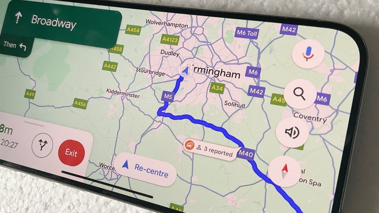
Google Maps on CarPlay
One of the most useful features in Apple Maps is how quickly drivers can report that there is, say, a lane closure, or there's been an accident. One of the most irritating things is when Apple Maps asks you if the incident is still there, and doesn't quite give you enough time to find out.
Nonetheless, it's a feature that has been helping Apple Maps users since 2021, and Google Maps on iPhone since 2019. However, the same Google Maps feature has been denied iPhone users, once they connect to CarPlay.
That would seem to be where it would be most useful, but for years, drivers have only been able to see other people's warnings, not report any themselves. Now according to 9to5Google, these incident reports are rolling out to CarPlay users.
It appears to be still rolling out, and it's not clear how long it will take to reach all users. Curiously, incident reporting is still not being seen when Google Maps is connected to Android Auto.
When it is available, drivers get an icon of a hazard sign. Tapping it brings up quick controls for reporting common issues, ranging from a crash or an object on the road, to construction or a speed trap.
The addition of this reporting feature comes shortly after a similar situation over speed in Google Maps. Google added a speedometer to Google Maps on Android around five years ago, and has now brought it to iOS.
Read on AppleInsider
Comments
As far as simply getting from populated point A to populated point B goes, they’re equal. The fit and finish of Apple Maps, the up-to-date hazard/slowdown colour-coding, and the more pleasing voice of Siri versus whatever they call the Google Maps voice are among the many small touches I appreciate, as well as the accurate estimated arrival times, the art style used for the 3D display of buildings and features, the offer to save time by re-routing, and more.
I regularly use Maps on trips even when I know the route by heart. Maps is very good at giving me early warnings of detours that I was not expecting. On one recent trip Maps/Siri simply said "Take the next exit!" without further explanation. On this particular trip my wife was ahead of me by about 30 mins in a different vehicle but ended up stopped for more than an hour and a half. I was able to avoid the blockage altogether. Of course Waze is even better in this regard, but only if you are near an area where there are people actively crowdsourcing live data into the app. I found it very useful driving around Boston, but where I live very few if any people are feeding in live data, especially the horse & buggy vehicles.
I also use Maps extensively to get information on local stores and restaurants before I head out because some of these venues have variable hours from day to day and different days of the week that they are open or closed. The venue's operating schedule and hours of operation are right there in the Maps app along with a link to the venue's web page and contact information. In the case of restaurants the menus are typically available on the restaurant's web sites.
I do occasionally use Google Maps but primarily when I want to post directions to a destination on a web page or via a QR code on printed media. It works fine for everyone including Apple, Microsoft, Android, etc., users. But Apple Maps is my go-to tool for navigation and location based discovery.
Also, neither map service offers superior data on locations (stores, local attractions, etc.). A little mom-and-pop store might show up on one mapping service but not the other.
As for navigation directions, that's spotty as well. I find myself using Google Maps more frequently in Japan than Apple Maps (the Japanese themselves have very frequently used their own GPS navi tools) but Apple Maps is very good where I live (California).
There's a lot of variability in quality between different transit modes. If we stay on the Japan example, I'd say Google Maps provides better pedestrian navigation than Apple Maps. Neither Apple Maps nor Google Maps is as good as native Japanese apps for transit planning. The JapanTravel iOS app is far superior than both if you are planning a trip between public transit stops as it will rank the trip options by best connections. Even if you can change lines at multiple stations, it will rank the options by the best connection (least time + shortest distance) and give fare information.
Kyoto has weird street addresses and if you cut-and-paste the kanji (not translated English) in both Google Maps and Apple Maps, the search results can be very uneven. Sometimes one service may not correctly identify the location. Major attractions, stores and eateries might be fine on both but a lot of the little stores do poorly. If you are looking for a particular restaurant, it's better to look it up on Tabelog (Japanese restaurant index service) as the map locations are almost always correct. Tabelog also provides specific information (like subway exit numbers) and walking distance (number of meters from subway entrance to restaurant entrance) that neither Apple Maps nor Google Maps provide accurately.
As for Europe, it depends. I often end up checking things on both services because it is clear there is no definite winner, or at least nothing that is obvious when one first arrives. That's a bummer because sometimes it takes far more time looking up things. Hopefully Apple Intelligence will speed things up by sampling both.
Back to the original topic, Waze has offered hazard reporting from its inception, before it was acquired by Google in 2013. As mentioned by someone else, Waze works best in places where there is an active base of Waze users. I've used Waze in places where it is apparently unpopular with locals which renders the hazard reporting system almost useless (like Tokyo). So a lot of the map service quality has to do with the adoption rate and quality of information on local points of interest.