Apple execs explain why you should use Apple Maps over competitors

Posted:
in General Discussion
A pair of Apple executives have touted the benefits of the company's new overhauled Apple Maps platform, including privacy, navigation improvements, and attention to detail.

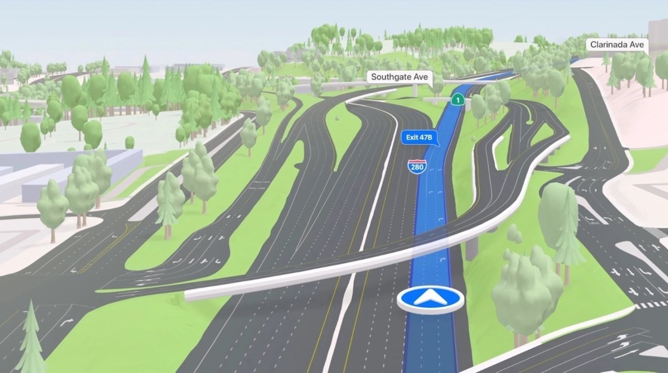
The new Apple Maps in iOS 15


Apple's product and design leads for Apple Maps, David Dorn and Meg Frost, recently spoke with CNN about the overhaul of the company's navigation app -- and, specifically, new features in iOS 15.

For example, Frost expanded on the improvements to directions and navigations in the new Apple Maps -- changes that apply to driving, walking, biking, and taking public transit.

"At a glance, drivers can understand a complex intersection more quickly than ever before," Frost said. "And that detail helps with that split-second decision of which turn they're going to make. So we want it to be both safer and visually satisfying to navigate."

Apple also added a 3D globe and 3D landmarks to Apple Maps in iOS 15. Frost said that the globe "accurately represents the size of countries," and added that the attention to detail to 3D landmarks extends to properly colored lighting on certain buildings.

The team created the landmarks by crafting a mesh of buildings and applying it to the underlying mapping system, which results in highly detailed and realistic 3D models. The 3D model of the Philadelphia Museum of Art, for example, has a statue of Rocky.

Additionally, Dorn detailed why consumers on iPhone should choose Apple Maps over competitors: privacy, tight integration with Apple's ecosystem, and the company's continued investment into the platform.

The end result of Apple's improvements to Apple Maps, Dorn added, can help take a "cognitive load "off of users and let them concentrate on getting where they're going.

Read on AppleInsider
«13

Comments

  • Reply 1 of 49
    If you live in one of the cities where Apple Maps has been updated with all that great UI in iOS 15, then yes - it's very good. The app overall has come a long way since the days where it would route you to a dead end. Public transit directions are also better in Apple Maps, at least in Portland, San Fran and Seattle where I've used them.

    I still have some frustrations with Apple Maps, but far less so than in past years:
    - Turn-by-turn navigation in Car Play is laggy, especially in situations where you need be in the correct lane from 4 intersections ahead or you'll never make your turn in heavy traffic. I find the app routinely reacting more slowly to reflect the turn and update the street than Google Maps does in Car Play - I would have turned already and made it 20 yards into the new street then Apple Maps would show it. 
    - The lack of offline maps makes the app unusable to me anywhere outside metro areas. The PNW is characterized by vast rural areas in the east of Washington and Oregon where cell service is spotty and sometimes even gas stations are 50 miles apart. Google Maps solves the issue with offline maps, what's taking Apple so long? Related, map quality just isn't up to par in rural areas, and that makes is very hard to use Apple Maps on road trips even when cell service is fine. I just still have anxiety it will route me to the wrong place outside the city. 

    Other than those two, of course the other one is collaboration on shared lists, especially with friends who just won't abandon Android! :) 
    edited December 2021 maltznarwhalcuriousrun8geekmeebyronldavgreghumdingerelijahgJWSCwatto_cobra
  • Reply 2 of 49
    BeatsBeats Posts: 3,073member
    heli0s said:
    If you live in one of the cities where Apple Maps has been updated with all that great UI in iOS 15, then yes - it's very good. The app overall has come a long way since the days where it would route you to a dead end. Public transit directions are also better in Apple Maps, at least in Portland, San Fran and Seattle where I've used them.

    I still have some frustrations with Apple Maps, but far less so than in past years:
    - Turn-by-turn navigation in Car Play is laggy, especially in situations where you need be in the correct lane from 4 intersections ahead or you'll never make your turn in heavy traffic. I find the app routinely reacting more slowly to reflect the turn and update the street than Google Maps does in Car Play - I would have turned already and made it 20 yards into the new street then Apple Maps would show it. 
    - The lack of offline maps makes the app unusable to me anywhere outside metro areas. The PNW is characterized by vast rural areas in the east of Washington and Oregon where cell service is spotty and sometimes even gas stations are 50 miles apart. Google Maps solves the issue with offline maps, what's taking Apple so long? Related, map quality just isn't up to par in rural areas, and that makes is very hard to use Apple Maps on road trips even when cell service is fine. I just still have anxiety it will route me to the wrong place outside the city. 

    Other than those two, of course the other one is collaboration on shared lists, especially with friends who just won't abandon Android! :) 

    Nah let android users suffer. 
    Anilu_777baconstangbadmonkwatto_cobra
  • Reply 3 of 49
    maltzmaltz Posts: 453member
    Every year or so, I give Apple Maps a try, and literally EVERY TIME I do, there's some problem with getting to my destination, and I hang it up again for a while.  Don't get me wrong, it's definitely improved over the years, and the features are great.  But not once has it taken me where I asked to go without some kind of convoluted route, or getting the location of the address wrong, or some other hangup along the way.  I still give it the benefit of doubt that it's partly due to back luck in the places I've asked of it, but... seriously.  I'm not even in a rural area - this metro is around 500k.  So I'm left to conclude that while the app might be great, its accuracy, at least in my area, leaves a LOT to be desired.

    My most recent attempt was just a couple of weeks ago.  It took me to the wrong end of the street in a neighborhood that's a year or two old.  Google Maps and Waze both got it right.  (Again, that was just one of half a dozen or so fails - some of which were in well established areas that haven't changed in decades.)
    curiousrun8williamlondonbyronldarkvaderJWSC
  • Reply 4 of 49
    For me, only Waze is worth using if I am driving. Google maps and Apple Maps lack user input and immediate updates for all kinds of things, but in particular, accidents, debris, emergency service vehicles and yes, the location of Police. Without these things those two are essentially useless for me when driving. Walking, biking and public transport is a different story.
    byronlAI_liasdarkvaderwatto_cobra
  • Reply 5 of 49
    Identifying the correct destination is definitely a weak area.

    plus why does the new version make it so hard to swap from overview to turn by turn!? There used to be a nice giant one tap at the top. Not so now. Try zooming in a little on overview and then getting back to turn by turn at a junction; too many taps of tiny buttons. Awkward. 
    williamlondonbyronl
  • Reply 6 of 49
    Apple Maps always works great for me in the US. But, when I travel, particularly using public transport in Europe, Google is the only way to go. Hopefully, Apple will eventually catch up on all the details. 
    byronl
  • Reply 7 of 49
    tommikele said:
    For me, only Waze is worth using if I am driving. Google maps and Apple Maps lack user input and immediate updates for all kinds of things, but in particular, accidents, debris, emergency service vehicles and yes, the location of Police. Without these things those two are essentially useless for me when driving. Walking, biking and public transport is a different story.
    There’s the report feature (it works only when you’re actively using Maps) so you can say if there is an accident or hazard on the road. When you’re driving and approaching one (or a speed/red light camera) it will tell you then give you the option to mark it ‘still here’ or ‘cleared’ (Toronto area, Canada). 
    george kaplangeekmeecypresstreeJWSCKuyangkohwatto_cobra
  • Reply 8 of 49
    jingojingo Posts: 117member
    Apple Maps has some really big UX fails which mean Imalways go back to Google Maps. In particular it is close to useless if you are the “navigator” while someone eslse is driving. A vast part of the screen is taken up with a panel showing details of the place when you search for a destination, and there are only two ways of seeing the map full screen (that I have found). Firstly you can click the X to close the panel, but then you lose the route. Secondly you can start the route, but there is no way of switching to a mode where you control what you are looking at, or lose the directions. 

    It surely should be possible to use it like a map book, but with the route displayed on it? This seems really fundamental to me but the UX designers seem to have almost wilfully stopped you from using it that way.

    Other things that bug me in CarPlay is that you can only have the display in dark mode or “automatic” when it seems to always be in dark mode as well. Why can’t you set it to always be in light mode? This doesn’t make any sense to me. The ideal scenario would be a quick and easy way to manually change it to the mode you want, not the mode that Apple seems to think you should want.

    Another failing is the difficulty in CarPlay of seeing what is coming up on the map a little bit further ahead than what is immediately in front of you. Viewing of the map is extremely limited.

    Finally another annoyance is that the warnings for speed cameras are only given when you are using it in routing mode. Why can’t you switch on the warnings even when you are not following a route?
    williamlondondewmeJWSCwatto_cobra
  • Reply 9 of 49
    Wonder how they want to explain it to Apple users outside of US… Sorry Apple, until you stop ignoring rest of the world, no way to use Apple Maps…
    williamlondonmuthuk_vanalingamgeekmeeentropys
  • Reply 10 of 49
    OferOfer Posts: 241unconfirmed, member
    The latest Apple Maps update that came out with iOS 15 stopped announcing all turns when I drive. Not sure how it decides which turns to announce out loud and which not. Since I want to keep my eyes on the road, I’ve stopped using it and switched back to Waze. May not be as “cool”, but at least it announces every single turn I’m coming up on so I don’t need to look down at my phone.
    williamlondon
  • Reply 11 of 49
    crowleycrowley Posts: 10,453member
    If you're lucky enough to live in the right place.  Where I live Apple Maps are solely lacking.  It won't even do cycling directions at all.
    muthuk_vanalingamentropys
  • Reply 12 of 49
    I’m Dutch, I ride a bicycle. But no Apple Maps for bike rides. That is very stupid. 
    williamlondonentropys
  • Reply 13 of 49
    Anilu_777 said:
    tommikele said:
    For me, only Waze is worth using if I am driving. Google maps and Apple Maps lack user input and immediate updates for all kinds of things, but in particular, accidents, debris, emergency service vehicles and yes, the location of Police. Without these things those two are essentially useless for me when driving. Walking, biking and public transport is a different story.
    There’s the report feature (it works only when you’re actively using Maps) so you can say if there is an accident or hazard on the road. When you’re driving and approaching one (or a speed/red light camera) it will tell you then give you the option to mark it ‘still here’ or ‘cleared’ (Toronto area, Canada). 
    The problem with the report feature is that it goes away too soon. It's hard to tell whether the accident is still there or cleared up until you just passed the location. Since keeping ones eyes on the road near a hazard is especially important, by the time I feel enough in the clear to want to report, I'm not able to.
    maltzwatto_cobra
  • Reply 14 of 49
    Apple Maps is definitely improved, and I use it almost exclusively. But the other day, I was downtown and Apple Maps got real confused when I was leaving to go home. I realize tall building can get in the way of signal, but it wasn't until I was well out of the downtown area before it got its bearing back. I never had that happen before.

    I sometimes fire up Google Maps or Waze just to check in on them. One thing I was hoping for in Apple Maps was the suggestions for parking in downtown areas like Google Maps made for me a while back.
    Fred257watto_cobra
  • Reply 15 of 49
    MplsPMplsP Posts: 3,924member
    I’ve been using Apple Maps almost exclusively in Minneapolis for several years and been satisfied overall. I wish it had the ability to easily add multi-point trips or add stops. Since I got a Tesla I use the tesla map far more as it’s far better integrated with the car. Apple Maps is also quite poor at locating EV charging stations. 
    darkvader
  • Reply 16 of 49
    I love the street light icons in the intersections.  Makes judging distance to a turn so much easier.  But my only issue is that i can't find a way to set that it to always uses the fastest route.  I have a number of places that i go that are quicker if i take a toll road.  But apple maps always works so hard to make me navigate around them.  Even if i change the route at the start, by the time i get there, it has updated to navigate around the toll road normally adding time to my trip.  

    Please give me a setting that always picks the fastest route. 

    MplsPwatto_cobra
  • Reply 17 of 49
    jingo said:
    Apple Maps has some really big UX fails which mean Imalways go back to Google Maps. In particular it is close to useless if you are the “navigator” while someone eslse is driving. A vast part of the screen is taken up with a panel showing details of the place when you search for a destination, and there are only two ways of seeing the map full screen (that I have found). Firstly you can click the X to close the panel, but then you lose the route. Secondly you can start the route, but there is no way of switching to a mode where you control what you are looking at, or lose the directions. 

    It surely should be possible to use it like a map book, but with the route displayed on it? This seems really fundamental to me but the UX designers seem to have almost wilfully stopped you from using it that way.

    Other things that bug me in CarPlay is that you can only have the display in dark mode or “automatic” when it seems to always be in dark mode as well. Why can’t you set it to always be in light mode? This doesn’t make any sense to me. The ideal scenario would be a quick and easy way to manually change it to the mode you want, not the mode that Apple seems to think you should want.

    Another failing is the difficulty in CarPlay of seeing what is coming up on the map a little bit further ahead than what is immediately in front of you. Viewing of the map is extremely limited.

    Finally another annoyance is that the warnings for speed cameras are only given when you are using it in routing mode. Why can’t you switch on the warnings even when you are not following a route?
    You may want to revisit your Settings. You should have a choice of Light, Dark, or Automatic. 
    JWSCwatto_cobra
  • Reply 18 of 49
    tommikele said:
    For me, only Waze is worth using if I am driving. Google maps and Apple Maps lack user input and immediate updates for all kinds of things, but in particular, accidents, debris, emergency service vehicles and yes, the location of Police. Without these things those two are essentially useless for me when driving. Walking, biking and public transport is a different story.
    Couldn't agree more. For anyone who lives in an area with regular heavy traffic, a navigation app is only as good as its real time traffic info and ability to route you the fastest way possible. And in this regard, there's Waze and then there's everyone else. Google maps isn't bad, no surprise considering that parent company Alphabet also owns Waze. But Apple Maps, with a smaller user base by far, just can't compete when it comes to real time traffic info routing. It's a shame, because I love the integration of Apple Maps with CarPlay and my Apple Watch, but neither of those matter much when the real time traffic info sucks. 
    AI_lias
  • Reply 19 of 49
    All of these complaints are valid.  
    I also think that your map usage requirements should drive your preference of map.
    I think it's best to think of Apple Maps as still-in-progress' or under continuous improvement.
    I wouldn’t want to be Google Maps looking over my shoulder at Apple Maps. 
    I do use these others when I find that Apple Maps fails in my small town usage of New Mexico. But that hasn’t happened over the past few years.
    But I still haven't changed my goal for maps, 
    which one would I want to teach my mother?
    edited December 2021 watto_cobra
  • Reply 20 of 49
    When Apple Maps includes offline maps like Google Maps then I’ll switch, but not a day earler.
    AI_liasJWSC
Sign In or Register to comment.