Apple Maps' Look Around feature works in three more U.S. cities

Apple has rolled out its "Look Around" feature of Apple Maps into three more cities in the United States, giving users the ability to see Boston, Philadelphia, and Washington, D.C. at street level on their iPhone or iPad.
Enabled on Friday, the latest trio of cities in Look Around is now available to view from within the Apple Maps app in iOS and iPadOS. The rollout is happening relatively rapidly and should be available to all users globally by the end of the day.
The addition of Boston, Philadelphia, and Washington, D.C. to the roster, as spotted by MacRumors, follows earlier rollouts in Houston, Los Angeles, Las Vegas, New York City, San Francisco, and Oahu. Apple hasn't offered a timeline for future Look Around updates, but updates seem to arrive every few months.
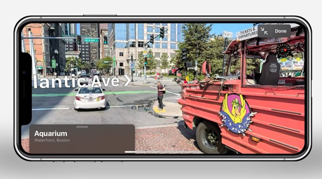
The feature, Apple Maps' answer to Google Maps' Street View, can be accessed by going to one of the locations where Look Around is available. After tapping the binoculars icon, a specific street can be selected and previewed in a small window, which can be expanded to a full-screen view by tapping the preview.
Once inside Look Around, the feature works relatively similar to Street View, in that the view can be changed by swiping the display, while tapping part of the road in the distance will move the camera to that point. Unlike Street View, Apple's version is more animated in its transition between locations.
Look Around is part of a relaunch of Apple Maps, which now offers a generally improved experience to users, including Apple-collected data and high-resolution 3D imagery.
Enabled on Friday, the latest trio of cities in Look Around is now available to view from within the Apple Maps app in iOS and iPadOS. The rollout is happening relatively rapidly and should be available to all users globally by the end of the day.
The addition of Boston, Philadelphia, and Washington, D.C. to the roster, as spotted by MacRumors, follows earlier rollouts in Houston, Los Angeles, Las Vegas, New York City, San Francisco, and Oahu. Apple hasn't offered a timeline for future Look Around updates, but updates seem to arrive every few months.
The feature, Apple Maps' answer to Google Maps' Street View, can be accessed by going to one of the locations where Look Around is available. After tapping the binoculars icon, a specific street can be selected and previewed in a small window, which can be expanded to a full-screen view by tapping the preview.
Once inside Look Around, the feature works relatively similar to Street View, in that the view can be changed by swiping the display, while tapping part of the road in the distance will move the camera to that point. Unlike Street View, Apple's version is more animated in its transition between locations.
Look Around is part of a relaunch of Apple Maps, which now offers a generally improved experience to users, including Apple-collected data and high-resolution 3D imagery.
Comments
although, to be fair, at this rate my city will be getting it around 2033.
Look Around support should start to build up at a fairly rapid pace, I'd think. The longest and hardest part is actually going out and collecting the data. Then, priority #1 is updating the actual map, once that's done for a city/region, then they can move onto Look Around. Which I assume takes quite a while to stitch all those images together and lay them over a 3D surface. Which is a huge difference from Street View which are just flat photos stitched together a'la QuickTime VR.
I'd love it if the next step is to use Look Around data to enhance FlyOver. It would be awesome to be able to zoom down from the sky right into Look Around. And then the opposite, jump up in to FlyOver mode.
The Googlers though are focus no what's next https://blog.google/perspectives/jen-fitzpatrick/charting-next-15-years-google-maps/
You would think with Google's lead Apple's first job to be done would be getting its map to global coverage and parity as soon as possible and pretty transions last, but then if they can make a lesser product seem superior I guess job well done ?
After using The updated Apple Maps for a few weeks now I’m liking it more and more. I don’t use street view much, but if you’re trying to figure out a specific route and need info about traffic lanes, parking, etc it’s very handy and Apple’s implementation is far superior to google’s.
That may be true, but street view is in 220 countries and territories, by the time Apple gets to that number "BAD GOOG" could have done pretty transitions on all 220 regions 3x over.
The Googlers though are focus no what's next https://blog.google/perspectives/jen-fitzpatrick/charting-next-15-years-google-maps/
You would think with Google's lead Apple's first job to be done would be getting its map to global coverage and parity as soon as possible and pretty transions last, but then if they can make a lesser product seem superior I guess job well done ?
Many people use both Apple Maps and Google Maps. I'll switch back and forth depending on what I need but I"m finding myself using Google less and less.
But even if it was nothing more than ‘pretty transitions’, anyone paying attention to technology for the last 20 years should have learned that things such as attractive visuals not only lead the industry, but other companies copy Apple visuals—or were you not around when OS X received criticism for its visuals only to have Windows eventually copy the idea and it completely changing the industry?
Humans aren’t machines. We enjoy ‘beauty’, even if that beauty is just a pretty transition in a maps app.
Which is extremely useful to find a new location. And is probably why they mapped both sides of the street.
Granted, Apple has a nice special effect when moving through photos, but I’d choose a reliable and complete set of data over that anytime.
And with Apple’s roll-out speed, it will take a decade before they get there.